


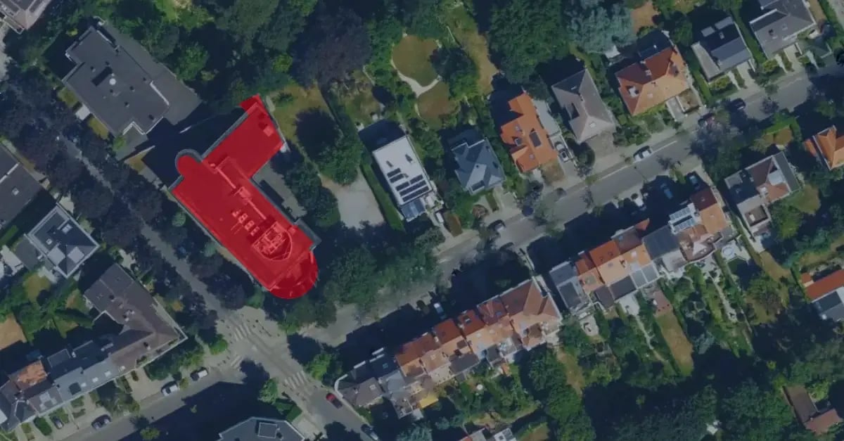
Understanding Building Footprints
A building footprint is a precise geometric boundary of a building (physical structure), very often associated with a particular point of interest, and shows the exact shape and position of a physical building on the Earth. Building footprint datasets contain the foundation's accurate size, shape, and location, i.e., longitude, latitude, geocoding level, and more, to precisely "describe" the building's position for all the mapping and navigation tools. Building footprints are needed to create polygons, which are then used for mapping and geospatial analysis, urban planning, navigation, disaster management, and more.
Building Footprints in GIS Mapping and Navigation
Building footprint data provides beyond-mapping information that transforms mapping and navigation systems insights into smart decisions. Conventional maps typically highlight roads and major landmarks, but footprint datasets offer location and dimensional data about buildings with exact precision and other details like geolevel, building type, and more. The specific building positioning information improves the geographic area analysis and enhances the navigation software functionality.
Such services direct users through building footprint data to their closest pick-up and drop-off locations. Passengers and drivers experience confusion in dense areas because this data is unavailable. Building outlines serve delivery companies to optimize delivery routes and discover entry points that minimize delivery delays and errors. A GIS mapping system benefits from building footprints that help to analyze and understand locations. Vector data represents buildings through layers in your map, which you can add or remove. Click here to find 3 detailed examples of building footprints in the US.

What Building Footprint Datasets Include?
A building footprint dataset typically contains:
- Exact building dimensions at ground level
- Exterior boundaries defining the enclosed space
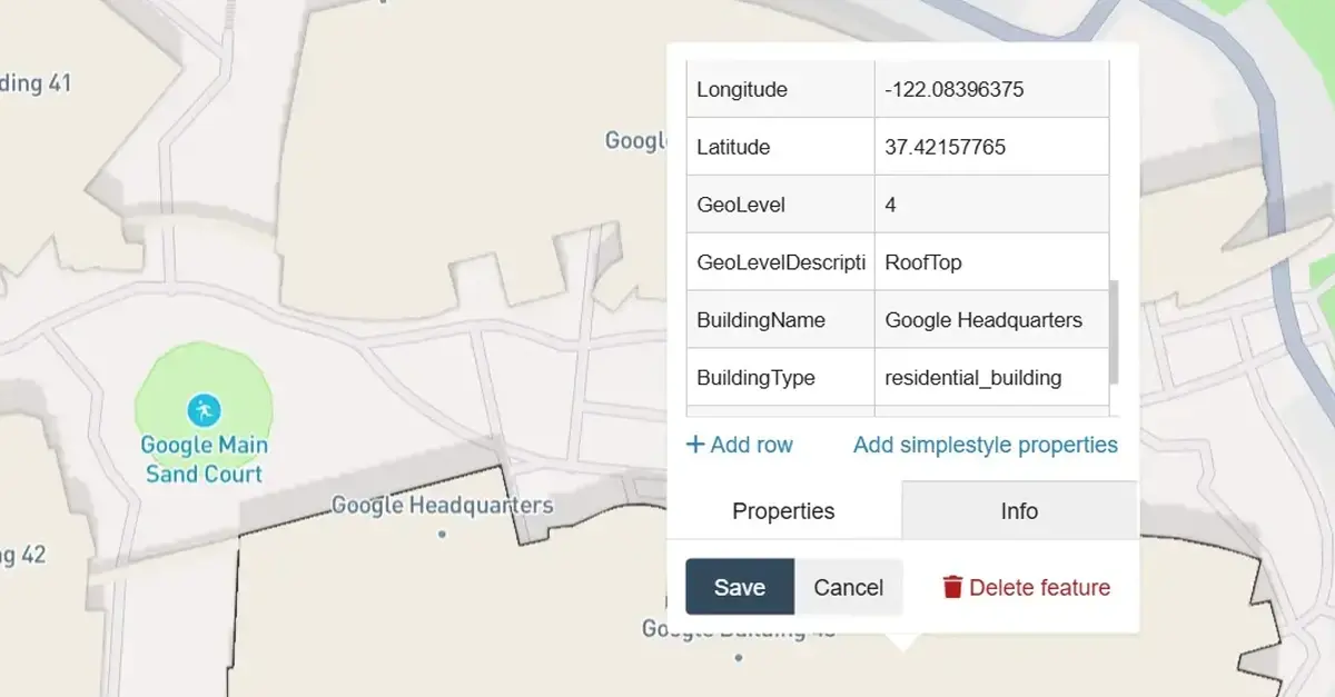
- Geographical attributes such as latitude, longitude, and geocoding level
- Building type classification (residential, commercial, industrial, etc.)
- Number of floors and height estimation for 3D analysis
By incorporating these elements, building footprint datasets provide a highly detailed and structured representation of urban and rural landscapes.
Why do businesses and government organizations need building footprints?
- Urban Planning & Smart City Development
City planners rely on building footprint data to assess population density, infrastructure needs, and zoning regulations. By mapping footprints, local governments can plan transportation networks, green spaces, and public facilities more effectively. - Logistics & Delivery Optimization
For delivery services, knowing the precise location and shape of buildings is crucial for optimizing routes and reducing last-mile delivery costs. Combining building footprint data with POI insights allows logistics companies to improve efficiency and fuel consumption. - Disaster Preparedness & Risk Management
Building footprints help identify structures at risk from natural disasters such as floods, earthquakes, and hurricanes. Emergency responders and insurance companies use this data to develop evacuation plans, assess damage potential, and allocate resources more effectively. - Commercial Real Estate & Retail Expansion
Businesses looking to expand analyze building footprints along with demographic and competitor data to find prime locations. Understanding foot traffic patterns, accessibility, and surrounding businesses helps companies make informed site selection decisions. - Renewable Energy & Sustainability
Solar energy providers use building footprints to identify rooftops suitable for solar panel installations. By evaluating surface area, orientation, and shading, they optimize solar power generation while promoting sustainable energy solutions.
Examples of Applications using Building Footprints:
- Traffic & Mobility Analysis
Transportation planners integrate building footprint data with POI datasets to optimize public transit routes, bike lanes, and pedestrian-friendly areas. This leads to better traffic management and more innovative mobility solutions. - Insurance & Risk Assessment
Insurance companies assess risk by analyzing a building's footprint in flood zones, fire-prone areas, and seismic activity. This helps them calculate accurate premiums and minimize financial risks. - Telecommunications Network Planning
Mobile network providers use building footprints to plan 5G infrastructure, ensuring optimal tower placement and signal coverage. Understanding building height and density helps reduce dead zones and improve connectivity. - Commercial Real Estate & Market Analysis
Retailers use building footprint data to evaluate property sizes, customer traffic patterns, and competitive landscape. This enables smarter real estate investments and strategic expansion decisions. - Environmental Impact & Climate Science
Building footprints plays a key role in environmental research, helping scientists assess urban heat islands, stormwater runoff, and biodiversity loss. Accurate mapping allows for better conservation and climate adaptation strategies.
How does POI data enhance building footprint analysis?
Combining Building Footprints with Point of Interest (POI) Data enhances decision-making in multiple industries:
- Retail & Real Estate – Understand customer movement patterns by analyzing footprints and nearby shopping centers, restaurants, and entertainment venues.
- Smart Cities & IoT – Integrate footprint data with sensor-based monitoring systems to improve urban infrastructure and resource distribution.
- Energy & Utilities – Optimize grid planning and solar panel placement using building dimensions and surrounding land-use data.
Frequently Asked Questions (FAQs)
What is a building footprint in construction?
A building footprint refers to the horizontal outline of a structure at ground level. It is commonly used in zoning, site planning, and real estate development.
How is building footprint data collected?
Building footprint data is collected from satellite imagery, LiDAR scans, GIS mapping, and property records. This data is then processed using advanced geospatial analytics.
What industries benefit from building footprint data?
Several sectors benefit from building footprint data, including urban planning, real estate, logistics, insurance, renewable energy, and telecommunications. These industries utilize this information for data-driven decision-making.
Can building footprints assist in flood risk assessment?
Yes, insurance companies and government agencies utilize footprint data to identify flood-prone areas, estimate potential damages, and develop mitigation strategies.
Does building footprint data include information about building height?
Some datasets do include details about height and the number of floors, which are valuable for 3D city modeling and urban infrastructure planning.
Conclusion: Elevate Your Geospatial Strategy with InfobelPro
Building footprints offer more than just a visual outline on a map—they are a crucial element of geospatial intelligence that supports smarter business decisions, urban planning, risk management, and sustainability initiatives.
With InfobelPro's Building Footprint Dataset and POI Data API, you gain access to precise, real-time, and scalable data that can enhance your operational strategies. Explore how our innovative geospatial solutions can transform your business today.
Final Thoughts
Companies need building footprint data to obtain precise geospatial information. The data provides many advantages to businesses for logistics optimization, retail expansion planning, and urban development initiatives. Companies that work with InfobelPro as their reliable data provider gain access to precise datasets. Companies use this data to maintain market competitiveness while enhancing their decision-making capabilities and discovering new growth possibilities. At InfobelPro, we have developed a range of high-resolution building footprint extraction techniques.


Comments